The rugged peaks and ranges in the heart of the Victorian High Country are a major drawcard for bushwalkers. The country here is consistently steep and rough; a marked contrast to the more rounded areas of the Australian Alps to the north-east. The jewel in the crown is the area located around Mount Howitt, a 1700m peak on the crest of the Great Dividing Range. Walkers flock to the narrow knife-edge ridge known as the Crosscut Saw, admire the views from Mount Howitt and enjoy the delights of Mount Speculation. Other landmarks in the area are less welcoming, featuring names such as the Terrible Hollow, Mount Despair, Horrible Gap, the Devil's Staircase, Mount Buggery and The Razor.
Most people access this spectacular area from the Howitt Plains, an alpine plateau located north of the remote mountain town of Licola. The high starting altitude provides relatively easy access to the area, and it is quite common to see young families doing day trips to Mount Howitt. It is also the starting point for one of the best four day walks in Victoria; the Razor-Viking circuit. Setting off from the Howitt Plains, this circuit heads clockwise around the crest of the mountain ranges, from Macalister Springs to Mount Howitt, across the Crosscut Saw to Mount Buggery and Speculation, down to Catherine Saddle, up over Mount Despair, across the southern flank of The Razor, then up through the cliffs to The Viking. From here bushwalkers descent from the ranges down into the depths of the Wonnangatta valley, before ascending 1000m back up to the Howitt Plains.
For those of us who live in Central Victoria accessing the Howitt Plains involves a rather lengthy drive that nearly circumnavigates the Alps. Instead, many of us opt to come in from the west via the town of Mansfield, saving several hours in travel. However, the reduced travel time comes at a price: altitude. Access from this side of the mountains involves starting from the valleys of the Howqua, Jamieson or King Rivers and climbing up to a thousand vertical meters to reach the crest of the range. It adds difficulty to the walks, but for some of us that's part of the attraction.
My goal for this trip was to complete the classic four day circuit from the west, starting and finishing at the Upper Howqua Camping Area.
Day 1 - Upper Howqua Camping Area to Mount Speculation
Following a late arrival in the wee hours of the morning, it took quite some effort to extract myself from bed and set out from the Upper Howqua Camping Area at 8am. The camping area itself was closed due to flood damage, with the old river crossing looking a little worse for wear.
The first 5km or so of walking entails following the Howqua River upstream along an old vehicle track. It's been closed to traffic for years, but some enterprising people in a 4WD have recently cut their way in along it. It required a substantial amount of effort in places, including filling in an erosion gully in order to get their cumbersome vehicles past.
Further upstream I noticed that the last remaining bridge on the track was missing, presumably having fallen victim to the recent floods. Fortunately others had provided stepping stones across the river instead, saving people from removing their boots for each crossing.
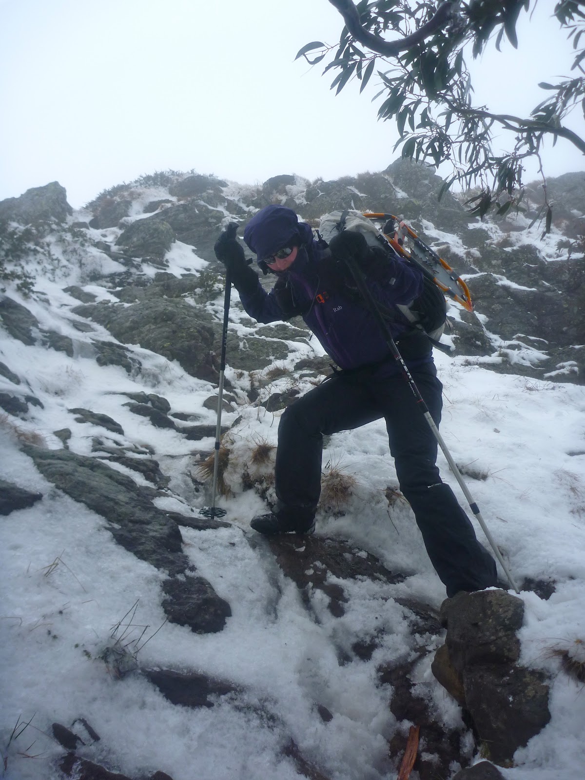
Upon reaching the base of the Howitt Spur walking track I turned left, following an old logging track up towards the crest of the Thorn Range. This track climbs at a steady pace but ducks and weaves all over the place, with false summits around seemingly every corner. At the actual crest I turned right along a walking track, heading up Stanley Name Spur. Passing over a slight hill and down through a small campsite perched in a saddle, the track then climbs straight up the side of one of the 'teeth' of the Crosscut Saw. The ascent is steep, and in places you need to use your hands to scramble up through the rocks - my kind of bushwalking!
After having lunch at the top of the spur, I set out along the well-worn foot track along the Crosscut Saw itself. The track ducks and weaves amongst the 'teeth', heading around some and straight over others. In places the ridge is quite narrow, making for spectacular walking.
The next major feature on the ridge north of the Crosscut Saw is Mount Buggery, with its rounded tree-clad summit providing an ideal campsite for those who are prepared to carry water. From the summit the track plummets down to Horrible Gap, before commencing a slightly gentler ascent up Mount Speculation. The south face of this mountain is particularly scenic.

One of the unique features of Mount Speculation is the amazing camping that is available, right on the edge of an escarpment overlooking the Terrible Hollow. I decided to take full advantage of this, so after resting briefly at the summit I headed north-east for a couple of hundred metres to a suitable location to pitch the tent. There were already a few tents set up, and I had seen a couple of parties making their way along the Crosscut Saw, so I staked my claim around 4:30pm and picked up some water from where the vehicle track crosses Camp Creek. Quickly cooked tea then went to bed at an early hour, hoping to catch up on lost sleep.
Day 2 - Mount Speculation to The Viking
One of the issues with camping in exposed locations is the drama that unfolds once the weather turns. Partway through the night the wind picked up significantly, to the point where I began to become concerned about the snowgums above my tent. Usually I have no problem with camping beneath snowgums as they usually only shed branches under heavy snow loading in the depths of winter. However, as I listened to each mighty gust of wind roaring in from the north and braced myself for each impact, I decided that it would be safer if I shifted my tent out of harms way in case the worst happened. Once this was done I could finally go back to sleep.
When dawn broke it was a glorious day, with the wind gone and nothing to distract me from the magnificent view from the campsite.
Broke camp and set off around 9am, opting to take the foot track along the ridge instead of the longer vehicle track. I was glad I did, as the scenery was magic. Spotted a fantastic chute down from the ridge into the Terrible Hollow, featuring a tight rocky entrance and an ideal orientation. I'd love to ski it someday.

The track follows the ridge for around 1km before plummeting down the steep side of the hill to reach the vehicle track near Catherine Saddle. This descent, although brief, can be hard on your knees and I think people attempting to climb up it would have significant traction issues. Upon reaching the vehicle track I followed it around to Catherine Saddle itself, noting that someone had been down here with a 4WD recently. As it turned out it must have been a Parks Victoria vehicle, as the track heading east from the saddle had recently been cleared. This made progress very easy all the way to the tree-clad summit of Mount Despair. Partway up there was a gap in the trees, offering good views back towards the Crosscut Saw.
Upon reaching the summit I had a break, and was about to pack up and leave when I heard a noise nearby. Looking around, I spotted a friendly reptile that must have wanted a bit of company.
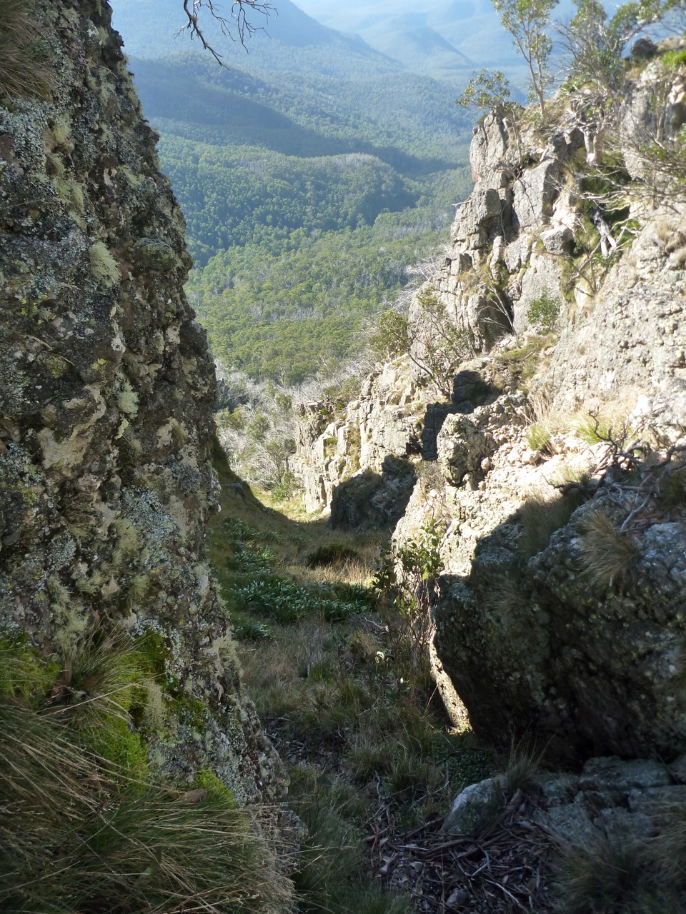
Descending from the summit, the track drops down to the crest of a rocky ridge leading to The Razor. The next stretch of track is very rugged and can be quite elusive. Generally the track sits below the crest of the ridge, but never drops down to the gully. Occasionally it gets close to the crest of the ridge, where there are views to the summit of the Razor itself.
Even though I'd walked this section of track before I still lost it towards the end, and had to climb up the hill to reach the ridge at the end of the Razor. Here I had a one hour lunch break, then continued along towards Viking Saddle. The track here had not been cleared, and regrowth through the decimated Ash forest was thick.
In places the track was hard to follow, but fortunately the second half of the track had been cleared, making the last section down to Viking Saddle itself quite easy. The saddle itself was as I remembered it, with the rocky cliffs of The Viking towering above it.
As I wanted to camp on the summit it was necessary to cart water from the bottom, so I set off down the foot track on the eastern side of the saddle, heading to the north in search of water to fill my containers. As on all my other visits to the area, water was found just before a little rocky escarpment that would form a waterfall after heavy rain. There must be a spring in the area, as not far upstream the creek bed was bone dry.
Returning to the saddle, I put the pack on and began the ascent up to The Viking itself. The ascent profile is similar to an exponential curve, starting off with a moderate gradient and getting steeper and steeper, until becoming near vertical towards the end where it passes through the rock band that forms the prominent cliffs. The track itself avoids the cliffs by heading up through a rugged chute, and in two sections passes through small caves formed by huge boulders.
At around 5:30pm I reached the summit, which is my favourite in Victoria. Despite its mere 1500m elevation, it feels like the top of the world.
I set off to the north and set up camp on a small grassy flat less than 50m away from the edge of the cliffs, started cooking dinner and then headed up to the edge of the cliffs to enjoy the sunset.
After the sun went down I could see the glow of a campfire down in Viking Saddle itself. If only the people down there knew what they were missing out on up at the summit. The temperature soon plummeted, so I retreated to the mild warmth offered by my 0º sleeping bag. It must have reached that temperature at one point in the night, as at some stage I woke up and the fly was covered in ice.
Day 3 - The Viking to Macalister Springs
Awoke in the morning to a heavy dew and a saturated fly. The clear skies of the previous day had been replaced by broken cloud cover, depriving me of a scenic sunrise.
Setting off a little after 8am, I climbed back to the summit and began heading towards the South Viking, when I heard voices coming up the hill. It turned out to be two bushwalkers from Newcastle, John and Claire. They had spent the night at Viking Saddle and were hoping to get back to the carpark at Howitt Plains that evening, so we decided to stick together for the day.
Upon reaching the top of the South Viking, we began descending the spur down to the Wonnangatta River. The regrowth was much more mild than the previous day, and there was a decent footpad in a lot of places. We made good time to the river, arriving before midday.
There was little trace of the old vehicle track that once headed along the river, and both banks were covered in large quantities of blackberries. This made progress slow, with the only compensation being that the blackberries were ripe... and delicious.
From the river we had two options; follow the old vehicle track up to the Zeka Spur 4WD track and trudge through the dust, or cut up an unnamed and untracked spur to intersect the main spur above the 4WD track. We opted for the former, in case we could hitch a lift, and to avoid any regrowth issues.
The Zeka Spur track is one of the main 4WD access routes into the remote Wonnangatta valley, and Easter is one of the most popular times of year. Consequently the track and all the vegetation either side is covered in dust, with the lingering scent of diesel in the air. We had a brief lunch and then commenced the march up the track, which is steep, uninteresting and generally unpleasant. Only two vehicles passed us going in our direction, and neither stopped. The rest of the traffic was heading down the hill. At one stage a vehicle pulled over and a lady called out, 'Are you guys intentionally walking?'!!! Says a lot about the 4WD mentality. We were relieved to find the intersection of the old track and the new, marked by a small stone cairn on a sharp bend.

At this stage we were starting to feel a little weary, but there were still a number of kilometres to go, so on we went. We came across a couple of walkers camped in a saddle, who had walked down the track to the Wonnangatta the previous day and marched back out again that morning. One of them described the ascent as 'soul destroying'.
Further along the track began to climb at a steady grade, and at one point there were views back to where we had come from earlier in the day.
The ascent seemed to drag on and on, and it was getting cold by the time we reached the intersection with the track into Macalister Springs. Here I bid the John and Claire adieu and set off towards Macalister Springs. The track in had been churned up recently by some sort of wheeled vehicle; apparently they have been doing some work on the toilet.
By the time I reached the campsite it was dark, and after briefly stopping to absorb some warmth from a roaring campfire I started searching for a friend of mine, Gary, who had walked in for the evening. The hut was packed with people singing campfire songs which wasn't my kind of scene, so I explored further and ran into Gary standing around another campfire with three others; James, Jolie and Natahl. I quickly set up the tent nearby and returned to the fire to cook tea and be social. As the evening wore on the temperature kept dropping and the fire got progressively smokier, and eventually my weary body decreed that it was time for bed. Fair enough too; it had been a 20km day with well over 1000m of ascent.
Day 4 - Macalister Springs to Upper Howqua Camping Area
The weather had deteriorated somewhat overnight, leaving the morning cold and damp. There were intermittent showers of rain and ice, but no snow. Gary left bright and early in the morning, opting to retreat to the warmth of Licola for a cooked breakfast. In the absence of a fire and amidst the rather cool air I could certainly see the logic of his plan.
James and Jolie kindly invited me over to their spacious Hilleberg tent for breakfast, an offer which I graciously accepted. Their tent had quite a sculptural form, seemingly emerging from the ground similar the rounded top of a deeply embedded granite boulder. The clean lines were broken by the many guy ropes protruding from the tent like spines from an echidna.
Following an unusual entry procedure that favours the more agile members of society, I found myself contained within its yellow and green walls. Natahl joined us, creating a close-knit environment that I felt quite comfortable in... until James insisted that I cook inside the vestibule.
Now, as an MSR liquid fuel stove user and somebody who can have a quite conservative nature, this is something I'm never comfortable doing. I usually only cook in vestibules in the snow, and only after the vestibule has been dug out to provide more space. As an added precaution I opt to prime outside, lest the stove flare up and cause harm. Everyone's heard, seen or knows someone who's been involved with a liquid fuel accident and I would hate to be the cause of such an event. So you can imagine my apprehension about cooking in a brand new, extremely expensive tent with a bunch of people I barely knew, running the risk of turning the whole lot into a molten mess of nylon and flesh in a matter of seconds.
James was extremely good natured about the whole concept, insisting being able to cook in the vestibules was his number one selection criteria when choosing a tent, and that he would be using his XGK in the vestibule anyway, so what was the problem? I still couldn't bring myself to potentially cause harm to the tent, and after more banter Natahl encouraged me to "live a little, burn it down!”
Well, her statement floored me. How could I defend myself against that? So, nervously, I lit the stove. There was no excessive flame. The tent still stood, intact. We were still alive. Life went on. Goes to show you how sometimes you build these mental barriers that seem insurmountable, yet often they really aren't that big a deal and be easily conquered using a different mindset. I reflected on Natahl's "live a little" statement a lot over the next couple of days, and am definitely a better person for it.
Amongst much conversation and many cups of tea we consumed breakfast in a social manner, and all too soon I had to leave, as there was still a few kilometres to go until I reached the finishing point. Farewelling my companions, I set off towards Mount Howitt at around 10:45am. Occasional breaks in the cloud allowed tantalising glimpses of the previous days walking, including some great views back towards The Viking.
As I neared the summit I was surprised to see an unusual object just metres away from the survey mark; a tent. Not something you see every day up there, and certainly not in low visibility with the wind blasting through.
Here I faced a difficult decision; to continue on over Mount Magdala and head back to the car via one of my favourite routes, Helicopter Spur, or to descend directly down the less pleasant Howitt Spur and then along the Howqua River. The low temperature and strong winds soon chilled me off, so I opted for the more direct Howitt Spur route. A small gap in the clouds allowed me one last glimpse back across to the Crosscut Saw to The Razor and The Viking, and then I began the descent.
The rest of the walk was fairly straightforward, and I arrived back at the car just before 2:30pm. A check of the GPS revealed that I had ascended 3,850m over the walk and had covered 62.8km.
Reflections
This walk was simply fantastic. Considering it was one of the most popular times of year the crowd levels were quite acceptable, and the terrain covered second to none. The third day was longer and harder than many would like, but I believe that for a fit party it is perfectly achievable. In future I would head up the untracked spur instead of the Zeka Spur track, and would finish the walk by heading over Mount Magdala and descending via Helicopter Spur on the final day.
With these minor adjustments I believe this would be Victoria's ultimate four day circuit.